The Perfect Storm of 1991: When the Atmosphere Aligned
Prepared with guidance from more than 30 years of professional television meteorology and weather-communication experience.
In late October 1991, a rare interaction among an Atlantic low, a powerful Canadian high, Hurricane Grace and the Gulf Stream created one of the most remarkable ocean storms in modern weather history.
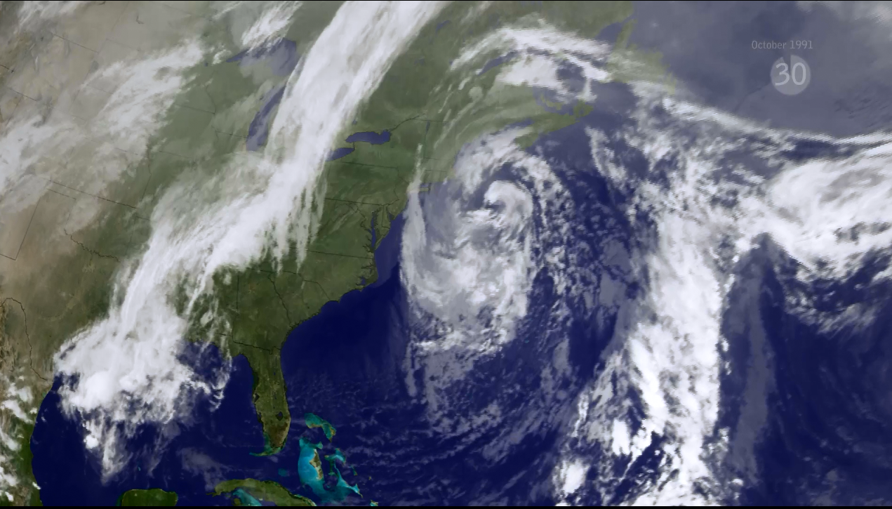
A storm with several ingredients
The storm remembered as the Perfect Storm began taking shape on October 28, 1991, when an area of low pressure developed east of Nova Scotia. Under more ordinary circumstances, the system might have become another strong autumn nor’easter. Instead, several atmospheric ingredients arrived at nearly the same time.
A cold front had moved through New England and entered the Atlantic. Behind it, an unusually strong high-pressure system intensified over eastern North America. The high reached approximately 1,046 millibars, creating a powerful pressure difference across the western Atlantic.
At the same time, Hurricane Grace was moving northward near Bermuda. Grace contributed tropical moisture and energy to the developing ocean storm. The low-pressure system strengthened rapidly as it drew energy from the frontal boundary, Hurricane Grace, the strong Canadian high and the relatively warm waters of the Atlantic.
Why was it called the Perfect Storm?
National Weather Service meteorologist Bob Case used the term “perfect storm” to describe the extremely unusual combination of weather systems. The name did not mean that the storm was perfectly forecast or that it was the most powerful storm ever recorded. It referred to the near-perfect alignment of atmospheric conditions needed to create an exceptionally dangerous marine storm.
The developing low southeast of Canada, the strong high to its north, cold continental air, tropical moisture from Grace and warm Atlantic water all contributed to the storm. Instead of moving steadily eastward and away from North America, the cyclone was blocked by the powerful high-pressure system. It turned westward toward the United States, a movement meteorologists call retrograde motion. That unusual track kept powerful winds and waves directed toward the coast for an extended period.
A dangerous ocean
The Perfect Storm became an enormous marine system. Hurricane-force winds generated tremendous seas across the North Atlantic. NOAA accounts describe waves exceeding 50 feet in parts of the open ocean, with some observations and estimates approaching 100 feet. Along the coast, waves reached approximately 25 feet in some locations.
A storm surge of roughly 4 to 5 feet above normal tides affected parts of the coastline. The storm’s slow movement allowed heavy surf to strike during several tidal cycles, increasing coastal flooding, erosion and structural damage.
The effects stretched from North Carolina through New England and into Atlantic Canada. Ocean swells were detected as far south as Florida, the Bahamas and Puerto Rico. The storm never needed to make a conventional United States landfall to produce widespread destruction.
The loss of the Andrea Gail
The storm is inseparably connected with the Andrea Gail, a 72-foot commercial fishing vessel returning from the Grand Banks. The vessel carried six crew members. Its last reported position was approximately 180 miles northeast of Sable Island, Nova Scotia. The ship disappeared as the storm rapidly intensified across the western North Atlantic.
The Andrea Gail was never recovered, and the exact circumstances of its loss remain unknown. An emergency beacon associated with the vessel later washed ashore on Sable Island.
The Coast Guard and other crews conducted extensive search-and-rescue operations during the storm. Numerous mariners were rescued from vessels caught in the extreme conditions, often at considerable risk to the rescuers themselves.
The loss of the Andrea Gail and its crew later became the central story of Sebastian Junger’s 1997 book, The Perfect Storm. A motion picture based on the book was released in 2000. The book and film brought worldwide attention to the event, but the precise final moments aboard the vessel could never be documented.
The storm became a hurricane
The Perfect Storm’s evolution did not end after it reached its greatest extratropical intensity. As the storm moved southward over the warmer waters of the Gulf Stream, its structure began to change. Thunderstorms organized closer to the center, and the system gradually acquired tropical characteristics.
By October 31, the National Hurricane Center determined that the circulation had become an unnamed hurricane. It reached maximum sustained winds of approximately 75 mph before weakening and moving into Nova Scotia as a tropical system on November 2.
This unnamed hurricane was not simply Hurricane Grace continuing under another form. Grace had already lost its independent circulation as its moisture and energy were absorbed into the much larger extratropical storm. The tropical cyclone that formed later developed from the center of the broader Perfect Storm. Forecasters left the hurricane unnamed because naming a system already receiving enormous public attention could have created additional confusion.
Was it well forecast?
Despite the storm’s extraordinary nature, the large-scale threat was recognized in advance. Ocean Prediction Center forecasters warned on October 27 that a major North Atlantic storm could develop within approximately 36 hours. The following morning, forecasters described the developing system as a “dangerous storm” in broadcasts to mariners.
The event nevertheless exposed the severe communication challenges faced by vessels operating far offshore in 1991. Marine forecasts were distributed through radiofacsimile, single-sideband radio, satellite transmissions and voice broadcasts. Access to real-time weather information was much more limited than it is today.
Modern mariners now have improved satellite observations, numerical forecast models, communications systems and wave guidance. Even with those improvements, rapidly intensifying ocean storms remain extremely dangerous.
The lasting lesson
The Perfect Storm was not produced by one isolated weather system. Its destructive power came from the interaction of the atmosphere and ocean across an enormous area.
It demonstrated how a tropical cyclone can contribute energy to an extratropical storm, how blocking high pressure can force a storm onto an unusual course and how prolonged wind over open water can build catastrophic waves.
More than three decades later, the Perfect Storm remains one of the clearest examples of how several individually recognizable weather features can combine into something rare, complex and deadly.